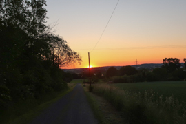
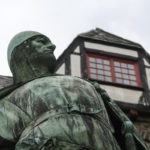
Where is the heart, the center of the European Union? There is really an official answer for that. The Institut Géographique National (IGN) in Paris is calculation the official midpoints of the Union, based on the center of gravity method. Since 2004, the midpoint of the European Union is located in Germany, located in different places. I visited all of them, three of them in late May 2020. It was a stunning trip, also through European history.
The European Union Midpoints before 2004
The first European European Union Midpoint ever determined was in 1987. The first two official midpoints are based in France, the next one is located in Belgium:
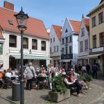
- As the midpoint of the 12 member European Union (i.e. Belgium, France, Germany, Italy, Luxembourg, Netherlands, Denmark, Ireland, United Kingdom, Greece, Portugal, Spain), the IGN determined the village of Saint-Andre-le-Coq in the Auvergne. It is a village of some 500 inhabitants between Clermont-Ferrand and Vichy. There is no memorial in the village.
- The reunification of Germany in 1990 made the midpoint move by some 25 kilometers Northeast. The new midpoint was a place called Noireterre in the village of Saint-Clement (also Auvergne). According to wikipedia, there is still a small monument.
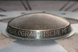
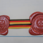
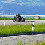
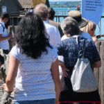
- In 1995, Austria, Finland and Sweden joined the Union. By that, the midpoint moved to Viroinval, Belgium, South of Charleroi and quite close to the French border. There is still a monument for that.
In 2004, the midpoint of the European Union moved to German territory (see below).
The European Union Midpoints since 2004
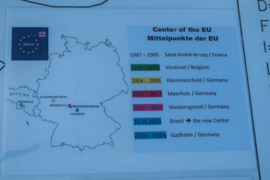
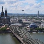
With the eastward enlargement in 2004, the midpoint of the European Union moved to Germany. The map below marks all four places, with reviews of all points underneath.
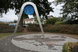
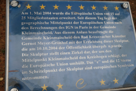
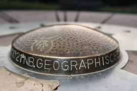
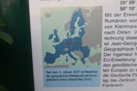
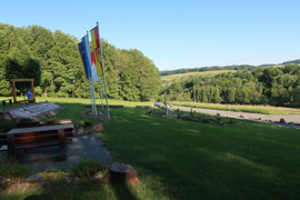
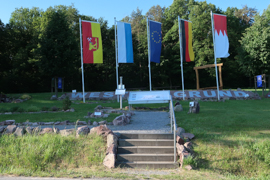
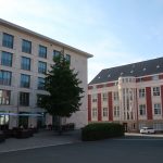
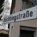
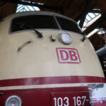
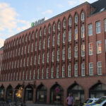
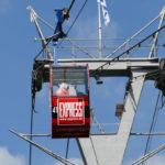
2004 – 2006: Kleinmaischeid (near Neuwied)
Kleinmaischeid is a small village which belongs to Neuwied county. You can easily reach it by car, it is just few kilometres away from the Dierdorf exit of the A3 motorway. Kleinmaischeid became midpoint of the European Union by the Eastbound enlargement of the union including Cyprus, Czech Republic, Estonia, Hungary, Latvia, Lithuania, Malta, Poland, Slovakia and Slovenia. The midpoint monument is located in the very center of the village, right next to the Bürgerhaus (community center), so that you just cannot miss it. There are also still some commemorative signs in the village.

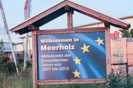
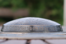
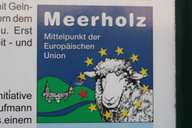
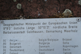
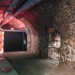
2007 – June 2013: Gelnhausen-Meerholz (near Hanau)
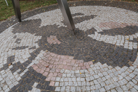
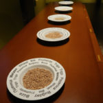
Meerholz is a borough of the city of Gelnhausen. When Romania and Bulgaria joined the Union on 1st January 2007, the midpoint moved to a wheat field right outside the village. There are signs when you enter Meerholz in memory of that time, it is however tricky to find the midpoint without preparation: preferably, you park your car at the Am Schwarzerlich road, from where you walk along a farm lane along the clay pit and turn right. On another website I saw that there used to be signs to guide you to the place, but they seem to be either very unfortunately positioned or taken down nowadays.
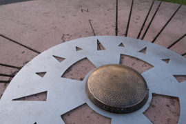
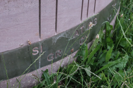
The midpoint is quite nice in its arrangement, but unfortunately run down. The blue “European Central Bank” has turned grey, the flags are taken town, but there are still some information signs. The key memory stone, which is showing the directions of all 27 (at that time) member states’ capitals, is in quite well conditions, though. There is also a small sign listing the member states on a small rock next to it.
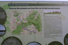
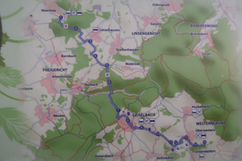
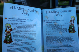
As Meerholz and the following midpoint, Westerngrund, are quite close to each other (even though they are in different German states, Hesse and Bavaria), there is a hiking route between those two places which is giving you some really nice scenery and information signs about all member states at that time. Unfortunately, it is a one way route with not too much infrastructure (like bus services) supporting it. The hiking route is managed by the Spessartbund, which is promoting hiking in the region.
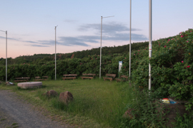
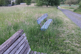
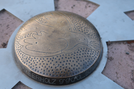
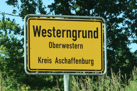
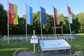
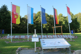
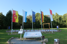
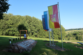
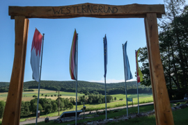
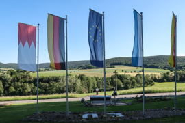
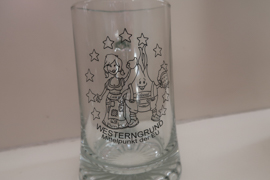
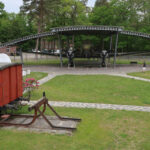
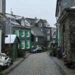
July – May 2014 // May 2014 – January 2020: Westerngrund (near Aschaffenburg)
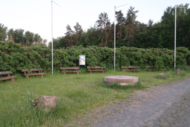
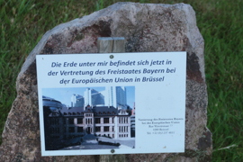
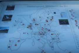
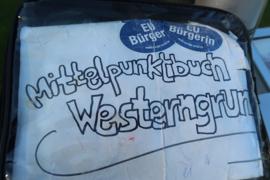
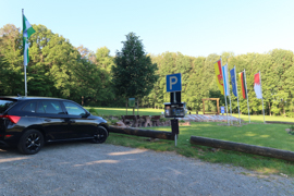
Westerngrund is a village in Aschaffenburg county. It is the only town which (so far) ever in fact hosted two midpoints of the European Union: on 1st July 2013, Croatia joined the European Union and the midpoint moved away from Meerholz to Westerngrund. This place, which is located at a hill, has unfortunately never been marked in any way as it was already known that the French overseas department Mayotte will join the Union about one year later, on 10th May 2020. This shifted the midpoint by 500 meters. This midpoint is maintained and managed privately by an organization. It is located at the Kahler Straße, you will find it quite easily as it is signposted at the village’s main road.
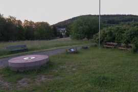
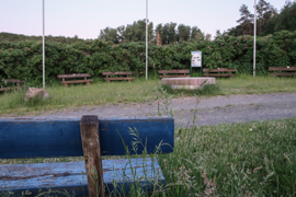
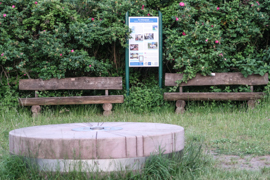
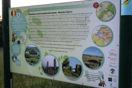
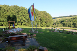
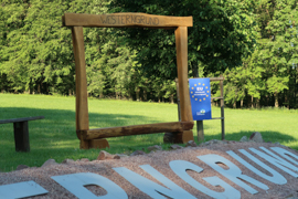
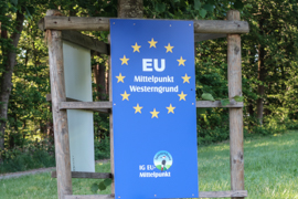
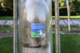
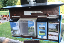
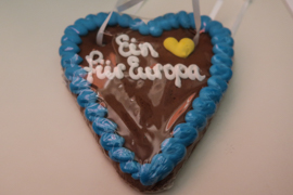
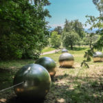
The midpoint is the most beautiful one I visited on my trip. The flags are still up, the scenery as such is really lovely and there are a lot of major and smaller nice features around. First of all, the midpoint has its own parking lot, which is very handy, but there is for example also a guestbook, which I felt to be a nice idea. A showcase shows the European Union and the other midpoints, including the current one in Gadheim (see below). There is also soil from all 27 member states at that time and soil from Westerngrund has been brought to some European locations. A very nice idea is the Westerngrund Frame.
You see that there is really a lot of love and engagement in the information provided. The information panel is holding quite some information in German, English, French, Polish and Chinese, for example.
It is the end of the EU-Mittelpunkte-Weg, the hiking route I mentioned before. There are also touristic information available (including a leaflet about that route, which you could not find in Meerholz). As said, this place is majorly driven by a private initiative and I felt very lucky to happen to run into one of the people behind that – I had a really long and good chat with him – and I am now even gifted with some midpoint souvenirs. Definitely love that and feel very thankful for them!
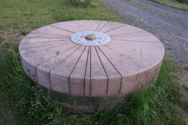
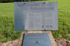
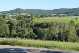
In case you want to tune your GPS, there is also a geodetic calibration point at this place. The last picture shows roughly the European midpoint on the next hill before the inclusion of Mayotte.
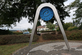
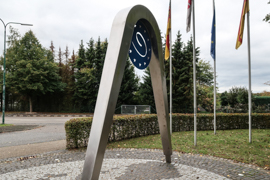
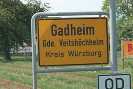
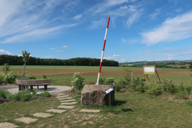
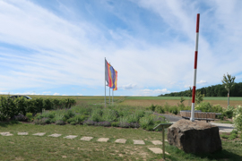
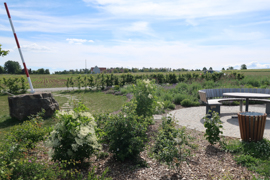
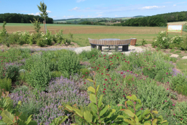
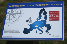
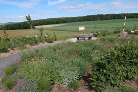
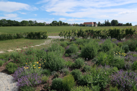
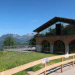
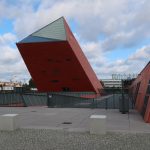
Since 1st February 2020: Gadheim (Veitshöchheim near Würzburg)
Since 1st February 2020, the village of Gadheim is the new midpoint of the European Union. The village is belonging to the town of Veitshöchheim and is some 15 minutes North of Würzburg (which also means that, funnily, all four spots in Germany are not too far away from the A3 motorway). There is a small sign about being midpoint of the European Union when you enter the village. The shift of the midpoint, of course, has some sad reason, as it has been caused by the Brexit.
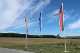
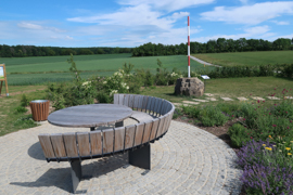
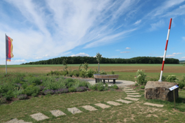
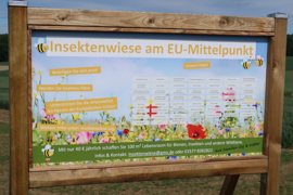
Gadheim’s role is quite new, so that there may be some change in the future, but they already created quite a nice place there, which is located on the Southwestern tip of the village. A pole is marking the midpoint, there are flags of the city, the European Union and Germany and a sign with all member states. They also did quite beautiful gardening around the spot, so that I really liked it, as well. They also seem to do some funding around the place, so that I could imagine that some more events and information will be added in the future.
Discussion about Midpoint Calculation
As said above, the midpoints listed in here are the official ones by the European Union. Of course, you could use multiple very different calculations from very simple to very sophisticated ones. You could for example simply connect the Northernmost and the Southernmost point, draw a line, do the same with the Westernmost and Easternmost point and take the intersection. For some other countries and regions, there is also something like the center of population. Due to similar reasons. Thus, there are here and there discussions about the correct midpoint of certain geographic areas. Sometimes, you may even want to “buy” a certain method so that your place gains the popularity.
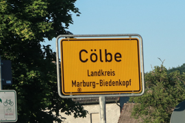
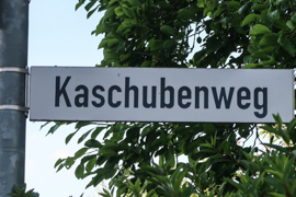
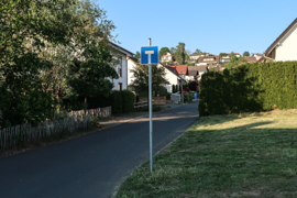
“Unofficial Midpoint”: Cölbe (near Marburg)
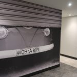
One of these unofficial midpoints is Cölbe near Marburg in Germany. The Bonn University Institute of Theoretic Geodesy defined in 2004 (i.e. under the conditions of the Kleinmaischeid “regency”) that a place at the Kaschubenweg is the real midpoint of the European Union. I visited the place, as I was curious whether the memory sign is still existing, but it is just an ordinary living area and the people rather feel to be pissed about it when you ask them about that topic.
The European Union Midpoints – My View
I hope I could take you on a small travel of European history in that posting. To me, it was fascinating that an in fact quite nerdy idea of traveling midpoints on the union also gives you so much history and also emotions. Bad luck that neither of the four places (maybe except of Gadheim, who just have that geographic honor for some months) really took the profit they could take of that opportunity. Especially talking with the Westerngrund organizers showed me how much interest there is in these place and how many people actually visit them.
Traveling in Germany
Here are travel reviews about places and sights related to Germany:
Escaping the heatwave in Germany a bit and being pampered in a luxury hotel with air conditioning - that was ...
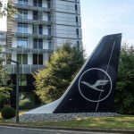
Meetings, congresses or trainings - the German airline Lufthansa has quite a bit of a demand for that. For that ...
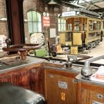
The Historic Tram Museum Cologne-Thielenbruch (Straßenbahnmuseum Thielenbruch) is a place which has been on my bucket list for quite a ...
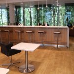
Spark is one of the latest Hilton brands, rather positioned in the budget-friendly hotel group sphere. After I had a ...
Despite I do have quite a decent flight history with Lufthansa, also on the intercontinental side, my list of flights ...
Despite I reduced my travel volume significantly due to health limitations, I still had some quite interesting flights during the ...
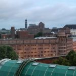
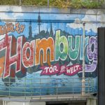
A workshop in January 2026 brought me back to Hamburg. It was held in a hotel in the Speicherstadt area, the ...
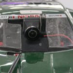
During my University time, I quite much enjoyed driving around with my RC (radio controlled) scale model car. Even though ...
Time for another food and service review post from my side. There were a lot of Icelandair flights on my ...
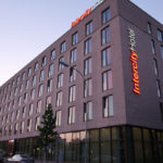
For my coverage of the 2025 FZ17 Floorball All-Star Game in Hamburg, I opted for another IntercityHotel option in the ...
It's time for another edition of my Food I Had Onboard. In January and February 2026, I did not fly ...
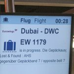
My recent two day trip to Dubai was meant as a mileage run, i.e. a trip which is majorly meant ...
I had quite a lot of interesting flights during December 2025 (and the beginning of January 2026),. Thus, there are ...
The final post of the year deals with nothing but the Best Ones. After I shared my Favorite Songs and Favorite Albums and EPs ...
Working for a client in Hanover gave me some business nights in the Northern German city. The second week I ...
As part of a two day workshop in Hamburg in November 2025, I had a night at the Motel One ...
I had quite a lot of travelling during November 2025. Thus, it feels like perfect time for a new episode ...
Sometimes, it is just nice to have a short vacation in your own own home town. My wife found a ...
My September 2025 edition of the Food I Had Onboard already starts with some experiences in late August. Again, there is ...
The Münchener Residenz ("Munich Residence") is one of the most iconic places in Munich. From 1508 to 1918, it was home of ...
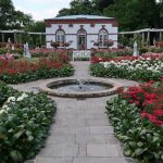
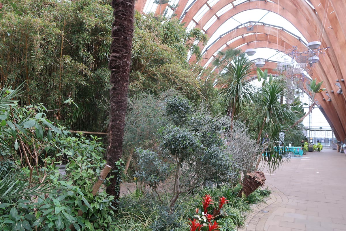
The Palmengarten ("Palm Tree Garden") is one of three botanical gardens in Frankfurt. It is one its key central recreational areas. During ...
Going to the Switzerland vs. India Tennis Davis Cup, my initial plan was to have an overnight in Basel before ...
In early August 2025, my wife and I made a quick Sunday excursion. As we wanted to make use of ...
Saturday noon rides with German national rail Deutsche Bahn typically give me a good chance for some lounge reviews. While ...
The 101 Best Hotels in Germany - that hardcover book was laying on the work desk when my wife and ...
I don't have that many flights during the summer season. Thus, the frequency of my Food I had Onboard posts is getting ...
For various reasons, including status prolongation at GHA Discovery, I did a one night trip to Frankfurt in August 2025 ...
Dusseldorf Airport (DUS) used to be a great place for plane spotters and aviation geeks. Two visitor terraces, one at ...
For a business trip to Munich in July 2025, I was looking for a cheaper stay in the area North ...
The Harz region will always be a special place to me. I studied mathematics at Clausthal Tech University and thus ...
For my rail trip to the 2025 Under 15 German Floorball Nationals in Bremen, I was looking for a centrally ...
The German book Der Struwwelpeter ("The Shock-Headed Peter") is one of the most classic and traditional German children's books. It has been ...
I really like flying to or from Munich Airport (MUC) or having a transfer there (at least in Lufthansa's Terminal ...
Two trips to the United States, including my 6 US States and Nashville trip and a short hop to see ...
During the last twelve years, I easily had something like fifteen to twenty nights in Las Vegas. Nonetheless, I was ...
Even though I comparably rarely stay in them, I typically like Leonardo Hotels. For a company event (rafting on the ...
Time to go home. The last somehow two days of my Six US States and Nashville trip majorly featured my ...
After I just gave you the preview of this trip so far, my road trip around Nashville was finally starting ...
In order to visit three Rock of Ages shows in Duisburg in May 2025 (not the one I covered as a photographer), ...
Due to my new job, I did not travel that much and worked quite a lot from home instead. However, ...
On my trip to Bremen and Stockholm in May 2025, I had quite some time to spend before a Rock of ...
Discover 400 million years of the history of Earth - that's what the Zeittunnel ("Time Tunnel") in Wülfrath is promising. On ...
If I would have to name my favorite player I have seen playing for "my" Pittsburgh Penguins, this name would ...
I had the idea to this post when I sat in the American Airlines Admirals Club at Pittsburgh Airport (PIT), ...
Even though they were struggling this season, Borussia Dortmund is one of the biggest names in German soccer. While I ...
Having a Thursday evening flight with British Airways gave me a comparably rare opportunity for a lounge review at my ...
As much as Lordi is the band I featured the most in my album reviews, Miniatur Wunderland is taking some ...
After I already took you on a Visitor Tour through Munich Airport (MUC) in a previous post, here is another ...
The 2025 Rock of Ages shows in Cologne (I visited all of them...) gave me the opportunity to have a closer ...
The Charité is one of the most famous and best hospitals in Germany. It is driven by the two key Berlin universities, ...
22 - a repdigit and thus a small anniversary in my Food I Had Onboard series. I have to admit that some ...
As the Run & Fly Meeting 2025 in Dortmund was held in parallel to a Borussia Dortmund soccer match and ...
Watching a friend's musical performance there brought me to Bad Säckingen in Southern Germany at the beginning of January 2025 ...
With my recent mileage run and the trip to the World Floorball Championship Qualifications in Italy, I had quite a ...
A mileage run is a flight or a series of flights which is majorly intending to gain miles at airlines' ...
Apart from the very inner city center, Stuttgart is a rather hilly German city. On one of their higher elevation, ...
I typically prefer Hilton Hotels and my second-most flown airport so far is Frankfurt Airport (FRA). Thus, it feels quite ...
While quite a lot of traveling is ahead of me during the next weeks, November and December 2024 was rather ...
In the frequent traveler community, especially in and around Germany, the middle distance Eurowings flights gained quite some popularity. Flights ...
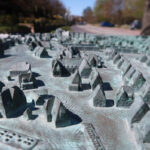
I simply love the Miniatur Wunderland. You can hardly challenge that the scale model landscape and rail attraction is the ...
has come to an end - and my Best of posting is the one which is "traditionally" concluding the year. The ...
Covering the opening of the "Goldenes Oval" and the Dresden vs. Weißenfels Floorball Bundesliga match took me to Dresden in ...
Being on some sort of Lufthansa farewell tour after I decided not to prolong my Senator status gave me an ...
In the second posting about the Autostadt in Wolfsburg, I take you to the VW ZeitHaus Museum (ZeitHaus translates to ...
On a Sunday in mid-August 2024, I visited the Autostadt ("Car City" or "Motor City"). Located in Wolfsburg in Germany, ...
Attending a conference in the city, I had one night at the IntercityHotel Mannheim. My typical choice, the Hilton Garden ...
Spending some time in and around Munich Airport (MUC), I also took the opportunity to have their Airport-Live-Tour, the basic bus tour ...
Having a hike with alpacas? This kind of free time activity becomes more and more popular, in Germany. Organizers argue ...
Exactly eight years ago, I flew SAS Scandinavian flight SK 626 from Dusseldorf (DUS) to Copenhagen (CPH). Not a really ...
As I didn't feel like taking the night ICE train after my August 2024 trip to Dresden from Berlin to ...
While my 18th edition of the Food I Had Onboard just came with a limited number of trips rather widely ...
I really enjoy riding the Railjet. The type of trains is majorly the backbone of the Austrian high-speed rail network ...
I haven't done a "Review Battle" for quite a while. Today, I am comparing two hotels of the same brand ...
Watching a musical show with a performer I know brought me to Bielefeld in September 2024. Due to my Accor ...
Wolfsburg might not be the first place which comes to your mind when you think about German touristic hotspots.. However, ...
From time to time, I simply enjoy having a night in Cologne, between two office days close to the office ...
I did not have that much traveling during the last weeks - but as some major trips are ahead, I ...
Being the only guest in a lounge almost demands me having a lounge review. This happened to me in Dresden ...
After I covered the Muxx.tv show by Jessica Lynn in Erftstadt, I felt that I should also just visit one ...
After I already introduced you to the Dresden Suspension Cable Railroad (Schwebebahn), it is urgently time to share my other ...
The Sauerland in the Western part of the German state of North Rhine Westphalia (Nordrhein-Westfalen) is very popular as a ...
Having a nice walk in the (somewhat) nature and meeting some animals out there - the weather was just too ...
In order to cover the German Athletics Nationals 2024, I needed to have a three night stay in Braunschweig. I ...
Getting a hotel in or around Mönchengladbach should typically be not too much of an issue. However, when I wanted ...
The German Olympic Sports Confederation (Deutscher Olympischer Sportbund) hired a complete stadium for their events during the Paris 2024 Olympic ...
Oh, I traveled too much the last weeks again. Time for another Food I Had Onboard posting - this time also featuring ...
I have stayed at the Mercure Hotel Düsseldorf Ratingen a couple of times before my night in June 2024. However, ...
Germany is famous for its car manufacturers. With Porsche and Mercedes, Stuttgart is likely one of the key cities car ...
As I am traveling to the United States rather frequently and also love to follow Feli from Germany (formerly German Girl in ...
A rail strike destroyed our travel plans in and around Munich in March 2024. Thus, on a rather short notice, ...
For Charles Esten's show in Hamburg in May 2024, I needed a hotel in the Northern German city. I chose ...
Munich is always a special place to me. As parts of my family roots are from there, I always feel ...
I had quite a lot of travel in recent times - so there is time for a new Food I Had ...
The history of Berlin nowadays is also a story of two airports which have been closed down in the meantime ...
After I had a one show stay in Vienna, it was already some three weeks since I had seen Rock of ...
Especially in summer, East Frisia and the East Frisian Islands on the German North Sea coast are very popular tourist ...
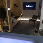
Meeting with friends in Troisdorf between Bonn and Cologne in the evening and relaxing at the Wellnest private spa Bonn ...
In my fifteenth edition of my Food I Had Onboard posting series, I have a quhttps://flyctory.com/tag/deutschebahn/ite nice range of flight and ...
After having visited their outlets in Essen and Cologne already, my wife and I made use of Good Friday 2024 ...
12th March 2024 brought me to Bochum in the German Ruhrgebiet. The city hosted my very first Rock of Ages ...
This year, I take you on my tour-chasing of the German Rock of Ages musical. The first trip report episode ...
At the time when I started writing this posting in early March 2024, Flyctory.com already featured reviews of over 320 ...
For the second part of my "review battle" of museums dealing with visions around the future, we leave the Museum ...
Typically, my trip reports are about one travel. Sometimes, there are one-day stories like the 24 hour train ride through ...
France, Tunisia, Saudi Arabia and Malaysia - I am just coming back from a massive aviation trip, which is the ...
The Selfkant is truly a remarkable municipality in the very West of the Federal Republic of Germany. The border to ...
As I knew it would be rather late after I visited the TSV Erlensee Floorball Bundesliga home matches vs. Dümptener ...
When I introduced you to the Audi & Siku Museum Höing about three years ago, you already saw that the ...
My trip to the handball matches at the EHF Euro 2024 preliminary round matches in Berlin did not feel being ...
Having dinner with some frequent traveler friends in Frankfurt lead to a one night stay in the German city, famous ...
There are a lot of zoos and animal parks in the Rheinland and Ruhrgebiet region of Germany. The TerraZoo in ...
After I had already flown the Airbus A320 simulator by Aerotask in Essen, I was really looking forward to my ...
Wernigerode being located right North of the Harz mountains might not be the most obvious location for an aviation museum ...
On 6th January 2024, I have been in Switzerland to cover two floorball matches, Zulgtal Eagles vs. Visper Lions and ...
Seeing one of the very first appearances of the Faroe Islands at a EHF Euro in handball just felt too ...
Happy New Onbaord-Food Year! At least, there is one flight experience from 2024 in this posting already, a Lufthansa Business ...
I already introduced you to the Museumkaart in the Netherlands, which may be a very profitable (but a bit of ...
Staying at the ibis Budget Aachen Raeren Grenze has been a hotel night I have been looking forward to do ...
As you know, I am very interested in iconic public transport systems. Thus, I had to visit the Schwebebahn, the suspension ...
Chinese lantern shows and other illuminations have become more and more popular in Europe during the recent winter seasons. In ...
Typically when I fly from the B Gates at Frankfurt Airport (FRA), I love opting for the Air Canada Maple ...
Before I have just been close to the NH Collection Hamburg City, I knew that this hotel will give me ...
The Nacht der Gitarren concert series with Jim Kimo West took me to quite some nice places in late 2023. I had ...
Wacken could be just a normal village on the countryside of the German state of Schleswig-Hostein. However, when you mention the ...
There are so many art museums and technical museums out there. However, do we really care sufficiently about the items ...
In order to cover the Home Free concert in Hamburg in September 2023, I had a night at the ibis ...
After my eleventh Food I Had Onboard posting majorly concentrated on two Lufthansa First Class legs between Frankfurt (FRA) and ...
TraMy trip in late October / early November 2023 involved a lot of traveling. Once I made it back to ...
Just as it felt convenient to stay somewhere closer to the office where I work, I had a night at ...
A very interesting part of visiting Heidelberg Castle is the Deutsches Apothekenmuseum, the German Pharmacy Museum. It is giving an illustrative ...
The two world wars have caused significant damage to most German cities - especially those with a somehow-strategical meaning. Thus, ...
Having a cheap hotel close to the main station after the Kelvin Jones concert in October 2023. My aim, when ...
In order to to cover the local Nacht der Gitarren show, I headed to Reutlingen in mid-October 2023. As the weeks before ...
Before we checked out the new Wellnest private spa in Cologne, my wife and I felt it is a good ...
I felt it is a good time to publish my next episode of Food I Had Onboard in this week in ...
After my wife and I overall had a nice stay at the Wellnest Private Spa in Essen, we were curious ...
Golf? In Germany, the sport is rather regarded to be elite entertainment, a free time activity for the rich. Our ...
Getting to the Seepark Biker Days 2023 in Pfullendorf required a rental car from Stuttgart Main Station to the town ...
When Swiss International Air Line recently released the seat map of their new Airbus A350 fleet, a real advantage of ...
I love small regional air service like the Essential Air Service in the USA or flights to small and rather ...
Are we really in the double digits now? I am really happy about my "new" category Food I had Onboard. Also, ...
The public transport situation of Dusseldorf Airport (DUS) is a bit more complex than it might feel at first sight ...
While covering the German Athletics Nationals 2023 in Kassel, I was looking for an accommodation near the hosting venue Auestadion. I ...
Looking for a hotel to cover the Seepark Biker Days 2023 in Pfullendorf did not give me too many options ...
If you think about famous German harbor cities, you might initially think of places like Hamburg or Kiel. However, Duisburg ...
The Bergischer HC is a handball club in the German Bundesliga. Visiting one of their home matches requires a bit ...
The website of the FC St. Pauli Museum states that a club like no other deserves a museum as no other. Indeed, ...
As part of my overnights bridging the night between two mandatory days at the office in Cologne, my last stay ...
The first day of our Iceland Ring Road trip brought my wife and I to the Air France / KLM ...
Just a week after I stayed at the Mercure Cologne City Friesenstrasse, I tried out another hotel of the Accor ...
Being on a five-day seminar in Lünen North of Dortmund lead to a comparably long stay at the Hampton by ...
What are you doing as a hobby travel blogger when your company (the professional work...) is requesting you to meet ...
Due to its harbor, Hamburg is a very important place for trading goods of all kinds. Not too surprisingly, there ...
NH Hotels are rolling out a new brand of hotels in Europe: nhow (pronounced as "now") is a group of ...
After I gave you three postings about the music at the Seepark Biker Days 2023 in Pfullendorf already, it is ...
I have to give in, that is not a normal posting. I felt that with any major anniversary for Flyctory.com, ...
One more Food I had onboard until I have a full set of ten postings. Hope you also enjoy reading ...
Right before my wife and I visited the Wellnest Private Spa in Essen during the Christmas holidays of 2022, we ...
The name of the German city of Wuppertal in the Bergische Land region near Cologne is indeed a perfect fit ...
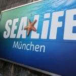
My visit at the Sea Life in Munich has still been under Covid-19 regulations. However, I feel that most of ...
Sad and touching moments just need to have a good hotel stay for your soul. For the very last leg ...
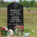
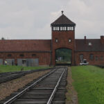
The former concentration camp site at Bergen-Belsen might not be as prominent as Dachau, but it is nonetheless one of ...
Oops, I did it again. Just within about a month, I feel that I had a nice volume of flights, ...
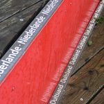
Germany meets Belgium and Belgium meets the Netherlands. Needless to say that also Germany and the Netherlands touch each other ...
Even though Accor is likely the second-most frequented hotel group in my bookings, a night in Bremen in April 2023 ...
Let's take you on a trip to Iceland. This is the first proper entry to my Trip Report, which takes on ...
Visiting Dortmund, my wife and I also headed to the Naturmuseum (Nature Museum) in the city of the German Ruhrgebiet. After the ...
Using public transport all over Germany for 49 Euro? Sounds like the perfect deal, especially if you are a visitor ...
Even though Heidelberg is a tourist magnet for many reasons, the Heidelberger Bergbahnen (Heidelberg Funiculars) are part of it. They offer you ...
In January 2023, I took a rail trip hitting all 16 German states in one day. Apart from that geographic ...
For a night after a photo trip to the Harz mountains in January 2023, I had a one night stay ...
Duisburg in the Ruhrgebiet might not be on the top of your list when you plan a trip though Germany ...
Attending a frequent traveler meeting nearby, I had the opportunity to visit the Hampton by Hilton Frankfurt Airport towards the ...
The last legs of the 2023 Weird Al Yankovic European Tour, Rock of Ages shows, the Pittsburgh Penguins and many ...
In order to explore Hamburg and upgrade my contents about the Northern German city, I had a two night stay ...
Back to my former home, the Harz mountains: watching two matches of the Red Devils Wernigerode, visiting my student residence ...
Even though Brühl right South of Cologne is just home of 45,000 inhabitant, there are mutiple major attractions in the ...
Damn, it is already four years... And it is more than 2,750 postings since then. On 25th February 2018, I ...
Wow, it's already half a dozen of episodes. This time, I start my Food I Had Onboard posting with two ...
For some reviews, I just need much longer than expected to find a good slot in my publication planning. One ...
After my - a bit of weird - trip of passing all 16 German states and eleven largest cities of ...
Bitburg is a comparably small town in the German Eifel region in West Germany, not too far away from the ...
What a day - on 14th January 2023, I traveled through all 16 German states in a 24 hour train ...
The night before the two floorball matches of the Red Devils Wernigerode against UHC Weißenfels (women) and the Berlin Rockets ...
How could the Christmas days end better than with some warmth, sauna, whirlpool and... wait... It will be damn full ...
AIthough has just been a day trip, but I just felt it is too long to tell the story of ...
Okay, I give in: this trip is weird. While people typically feel that I am "just" a die hard aviation ...
I felt that the current discussions about the closing down of the village of Lützerrath in Germany are a good ...
For a trip to Pinneberg just outside Hamburg, I needed a stay close to one of Hamburg's regional train stations ...
Even though one of my early Flyctory.com posts was about my B777 Singapore Airlines First Class experience, it took me ...
The Wasserturm in my home town Cologne is indeed one of the most iconic hotels of the city. Literally, the ...
Dud you ever feel like learning more about the current operations and future plans of Germany's largest airport? Frankfurt Airport ...
A trip to a Frequent Flyer meeting lead to a post about train rides: Less than two weeks after the ...
The German amusement park Phantasialand is regularly rated to be one of the best and especially most atmospheric spots of ...
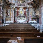
Asam Church in Munich is regarded to be the most beautiful church in the Bavarian capital. Thus, on one of ...
I like Hamburg - and especially in recent times, I have been very frequently around the Reeperbahn region. There are ...
March 2020 changed my life. Covid-19 temporarily took me quite a bunch of habits, which I felt to be essential ...
Even in the United States, you nowadays run into the green coaches of Flixbus. The company turned out to dominate ...
The Pergamonmuseum is one of the key touristic places in Berlin. The museum features over 250,000 objects of German-lead excavations ...
Especially when I visit large places for Flyctory.com, which give me a lot of memories - and pictures - I ...
Time for another episode of Food I had onboard. Between September and November 2022, I had some really interesting experiences, ...
The Reeperbahn area in Hamburg's borough St. Pauli has undergone quite a significant transformation. Some decades ago, the red light and ...
There are two major soccer clubs in Hamburg - and they are so different. If you look at their national ...
Unexpected encounter in October 2022: right when I was about to have my first Eurowings Discover intercontinental flight to Tampa ...
The 7th November 2022 is one of these days I will hardly forget so quickly. In a Weird Al fan ...
After staying at the Road Stop Motel in Dortmund, my wife and I were really curious about exploring another outlet ...
It's already quite a while ago since I visited the Deutsches Jagd- und Fischereimuseum, the German Hunting and Fishing Museum, in ...
The Hohensyburg castle is located at a height of 245 meters above sea level in Southern Dortmund in Germany. While the castle ...
I had a couple of private spa experiences with my wife already, like the MyWellness in Cologne or the Pure ...
The OFD (Ostrfriesischer Flug-Dienst) is a regional airline, which is specialized in connection the German North Sea islands. Being part ...
Already the fourth edition of my Food I Had Onboard category. Even though my Covid-19 infection changed quite a lot of ...
Lüdenscheid in the Sauerland region of Germany, Southeast of Dortmund, might not be on the top of the list when ...
In the order of posting the episodes of my trip report of exploring Hamburg Habor (here is my overview posting ...
This episode of my Hamburg Public Ferry trip report takes you to my favorite route of all, Line 73 (see ...
The second posting about exploring Hamburg with the HADAG public ferries features Line 72, which is special in multiple aspects ...
Typically, my Trip Reports are like travel diaries. One posting per day, telling you all the stories of a trip, ...
Saving my Melia frequent traveler points and doing some research for Flyctory.com were two really good reasons to try out ...
BMW - the Bayerischen Motoren Werke are definitely one of the most famous companies of Munich and a synonym for German ...
My review category Hotels & Accommodation in fact only features hotels so far. Thus, the review of Holiday Home Wonderland is some sort ...
The museum at the Schwelmer Straße 41 is not exactly at birthplace of Wilhelm Conrad Roentgen - but it is just a ...
The harbor area is the heart of the German city of Hamburg. The history of the city is closely linked ...
The area around Trier is holding a bunch of records for the oldest buildings and structures in Germany. The rationale ...
Okay, I have to give in from the very beginning: I love my home town Cologne - and this my ...
I enjoy visiting museums, which deal with other topics than the ones you find practically everywhere - arts, technology, biology, ...
At the beginning of July, my wife and I visited the LWL Freichlichtmuseum Hagen, the LWL Open Air Museum in Hagen. The ...
Going to Frankfurt by rail after work, watching a concert there and taking an early morning train back to Cologne, ...
During the Nazi regency in Germany, the Emslandlager (Emsland Camps) was a group of concentration and detention camps in the Emsland region, ...
At the beginning of April 2022, I had two nights in Hamburg. As one of my key intentions was to ...
Every year, some time in June or July, I am spending hours and hours looking into flight schedules, checking out ...
During my summer 2021 daytrip to Helgoland, I also needed the Dünenfähre ("Dune Ferry") to connect from the main island to the ...
The Bergisch Coffee Table (Bergische Kaffeetafel) is a traditional meal, somewhere between a brunch and an afternoon tea. And: it ...
A museum about pigs? Indeed, that's something you can do when you are in Stuttgart. Interestingly, the former slaughterhouse is ...
A museum full of computer games and gaming history? The German capital can offer that one! Right in the city ...
Early summer 2022. After the Covid-19 crisis feels to have come to a certain end, air travelers all over Europe ...
Doing some shopping (including the local sweets outlets) and visiting the Drielandenpunt, where Germany, Belgium and the Netherlands meet, I recently ...
Siegsdorf between Rosenheim and Salzburg in Bavaria might be a rather typical spot for that region: a rather nice city, ...
The Deutsches Museum (literally: "German Museum") is an amazing technical and scientific museum in the heart of Munich. While I just did ...
If you are not a general aviation pilot and "just" an aviation nerd or traveler, flying Helgoland Airport (HGL) is ...
Ritter Sport is one of the most famous German chocolate manufacturers. It has been founded in 1912 in Cannstadt, which ...
Greetsiel is one of the popular villages in East Frisia, right at North Sea. Especially the picturesque harbor area is ...
Even though Mannheim is not too much of a touristic highlight in Germany, it is a very important rail traffic ...
After my second posting about Food I Had Onboard in mid March 2022, I had a couple of interesting flight experiences ...
During a trip to the German North Sea shore in later 2021, we also visited the Automobil- & Spielzeugmuseum Nordsee. The ...
The last entry of my (multi-day) trip reports is typically a bit of boring. Getting to the airport, flying back ...
Campers, motor homes or recreational vehicles - no matter how you call do have your hotel room with you during ...
The reason why I traveled to Hamburg in March was a German show of my favorite musical Rock of Ages in nearby ...
I feel that one advantage of Flyctory.com compared to significantly larger travel platforms is that I can also take you ...
There are quite some reasons to visit the Western German city of Aachen. However, before I spend a night there ...
Already the partners of the project and new Hamburg attraction Yullbe Wunderland sound amazing: on the one hand, there is ...
After the end of World War II, the blocking of access to West Berlin by the Soviet Union (the so-called Berlin ...
For the first night of a trip to Stuttgart, I opted for the Hampton by Hilton Stuttgart City Centre. The ...
I already introduced you to the Visiodrom in Wuppertal, for which a former gasometer has turned into an audiovisual exhibition ...
After Day 9 featured the last real travel highlights including the Opry show, the last entry of any multi-day trip ...
Germany between World War II. - this is roughly the mission of the House of the History of the Federal ...
As I have been in Berlin but could not and did not really want to do a full coverage of ...
Even though the city is not overwhelmingly large, Solingen in fact comes with two zoos / animal parks. While I ...
After I got some quite nice feedback about my first Food I Had Onboard posting, I felt to continue this ...
Apart from regional local soccer dominator Borussia and the coal production history, Dortmund is quite well famous for a very ...
One of the architectural witnesses of the industrial heritage of the Rhein-Ruhr Region in Germany are definitely the gasometers. These ...
The region of Stuttgart is one of the key car manufacturing areas of Germany. Thus, it has been not too ...
In January 2022, I had a rail trip to Munich. As I arrived rather late, the Hampton by Hilton Munich ...
What has started as Stuttgart 21 - the refurbishing of Stuttgart Main Station including changing the main travel direction and putting ...
Doing Christmas shopping with a hotel room around? Right next to Germany's largest shopping mall, the Westfield Centro in Oberhausen, ...
As I purchased a Merlin Entertainment annual ticket for Germany in May 2021 (majorly as I have been covering Heide ...
I have been a bit of puzzled when I arrived in Munich in late January 2022, learning that the Stammstrecke, the ...
Flyctory.com has a focus on country music, my community includes quite a bunch of US-American people and I love to ...
The Hilton Hotel Group is currently opening quite a lot of new Hampton by Hilton Hotels over Central Europe. Sufficient ...
Especially when I am in London, visiting a stage play is always a must on my list (time permitting). One ...
Even though it is a some 50 kilometer drive from Cologne to Gummersbach, the VfL Gummersbach is not only the ...
Due to its rather hilly geography, the German city of Stuttgart has some quite iconic public transport systems. During a ...
The Lokwelt Freilassing is one of the most famous train museums in Germany. During a trip through Bavaria, I had ...
After I recently made you familiar with the DoubleTree in Milton Keynes, which is located right inside a soccer stadium, ...
Inhabitants of East Frisia drink ten times more tea than the average German - with their consumption of the hot ...
Hauptstadt der Spione - "Capital of the Spies". This is a book, which you can buy at the souvenir store of ...
One of the things I always try to do when in the United States is to spend some time at ...
In order to collect some new material for Flyctory.com, I recently drove to Remscheid to cover some museums there. The ...
Yes, I do like flying - but I am also a fan of rail travels. Just to find out how ...
The Tränenpalast ("Palace of Tears") in Berlin is the former border crossing point between East and West Berlin. It is located at ...
One of places my wife and I really loved to visit in pandemic times are private spa suites. We already ...
Oberhausen might not be regarded to be one of the most beautiful cities of the German Ruhrgebiet region - but ...
Ten years of happiness (and all the other times) with my wife - we originally intended to celebrate this very ...
Even though I do have a couple of airport reviews on Flyctory.com, I so far missed a lot of the ...
As I already told you last year when I reviewed the Charles Dickens Museum in London, I am a huge ...
Due to rail strikes, I had to re-plan my whole trip to Frankfurt Airport before heading to Canada. I finally ...
In October 2021, on a flight from Munich (MUC) to Keflavik Airport (KEF), I decided to go for a new ...
The Sustainability district, which is marked in green on the Expo 2020 map, featured some really interesting pavilions during our ...
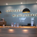
The Aquarium is one of the attractions of Wilhelmshaven. During a visit in summer 2021 under Covid-19 conditions, I visited ...
In July 2021, I wanted to explore some of the rather centrally located attractions of Berlin. Due to its good ...
As Munich Airport (MUC) is one of my most traveled ones, I know the business lounge situation there quite well ...
For a trip in July 2021, I needed a night close to Lübeck Main Station in Northern Germany. The H+ ...
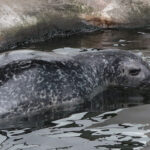
The Nationalpark Wattenmeer (Wadden Sea Conservation Area) is one of the most popular natural reserves in Germany. However, many young seals ...
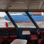
If you are in Hamburg, a Hafenrundfahrt (or: harbor cruise) is one of these must-dos in the largest city in the ...
Parking fees at Dusseldorf Airport got ridiculously high in recent past. For my August 2021 trip to Poland (from Thursday ...
I already introduced you to the lovely regional airport of Lübeck (LBC), a city some one hour Northeast of Hamburg ...
From outside, the Auto & Traktor Museum Bodensee ("Car and Tractor Museum") at Lake Constance looks like a traditional old farm ...
For my trip to Canada on the day they re-opened their borders after Covid-19 restrictions I went for Condor. I ...
Madame Tussauds is a global franchise - not too surprisingly, they also have an outlet in the German capital, Berlin ...
The Pictured Story postings give me a nice opportunity to share moments with you, which might not be worth a proper review ...
Arriving late from my Lübeck Air flight from Lübeck Airport (LBC), heading out early for my train to Bolzano in ...
More than 5,000 small buckets one next to another in a bunch of aisles within one store. The contents: interlocking ...
A lonely place with North Sea view (or, at least, a bit of that) - doesn't sound too bad, does ...
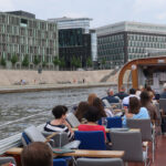
Doing a cruise on Berlin's key river Spree is one of the classic touristic options when you visit the German ...
Apart from several stays around the terminals, Frankfurt Airport nowadays features four airport hotels with direct walk-in connection to Terminal ...
If you think about oil producing countries, you may think about the USA or the United Arab Emirates. In fact, ...
Driving a model landscape or a large model train landscape in Germany is a difficult business: Even if you do ...
There was a duplicate reason to visit the European Hansa Museum in Lübeck in late July 2021: apart from the ...
Not only because auf an early 1990's video game, I am deeply interested in the Hansa and its history. Thus, ...
I received comparably quite a lot of feedback after I posted a review of MyWellness in Cologne. The place in ...
I remember having a flight from Lübeck / Lubeck Airport (LBC) in the very early 2000's. At this time, I ...
At the end of an interesting trip in June 2021, I stayed at the Mercure Hotel Hannover (Hanover) City. I ...
In mid June 2021, I again had a night in Hamburg. As I was aiming to come back late from ...
15 meters of total height, thereof a the height of the light itself at eleven meters - the Pilsum Light ...
Even though Solingen is not a that major city (some 160,000 inhabitants), it features two mid-size animal parks / zoos ...
It is almost needless to say that Adolf Hitler was obsessed with megalomanic ideas. Apart from ruling the world and ...
For years, if I would have wanted to deeply bash the Deutsche Bahn (German Rails), there would have been a simple way ...
Especially after all the Covid-19 restrictions, my wife and I were really looking forward to two relaxing hours in a ...
Have you ever heard of Surströmming, Hakarl or Spam? Do you mind eating eyes or drinking cow blood? All these ...
Since I agreed to the suggestion of a friend and started to also write reviews of car rentals, Sixt happened ...
Northern Germany, especially the East Frisia (Ostfriesland) region in model scale? This is exactly what the Leeraner Miniaturland (liternally: Leer Model Land) ...
If you know the name Carlo Pedersoli by heart, then you are likely ready to head to Berlin since 27th ...
A Panoptikum is a place for everything you can see, if you translate it roughly. The Hamburg Panoptikum in St ...
For a trip to Lower Saxony in early June 2021, I needed a stay in Hanover / Hannover close to ...
Majorly in order to check out the DAT (Danish Air Transport) connection from there to Hamburg, I happened to fly ...
Helgoland (in English also called Heligoland) is very often referred to as Germany's only deep-sea island. Even though this nice ...
There is always (mostly?) a second chance at Flyctory.com: After I haven't been too pleased with my first ever IntercityHotel ...
During my recent daytrip to Berlin, I took the opportunity to have a walk through sunny - and empty - ...
At the beginning of June 2021, I had a trip to Northern Germany. Apart from two nights in Hanover, I ...
Even though I had to delay my flight from there for medical reasons, I was really excited to have my ...
"Why are they allowed to open and we not?" - one of the most frequently asked questions during the Covid-19 ...
I have always been wondering how people from cities like Lockerbie or Lakehurst deal with the faith that their hometown ...
Historic panoramic painting fascinated me massively the last months. I already introduced you to the Panorama Mesdag in The Hague ...
My trip to the Bodensee / Lake Constance region in summer 2020 brought me to a surprisingly large number of car ...
Magnetic levitation is such a fascinating technology - and even though the German Transrapid project is no longer followed, it still ...
As the reviews of the park were pretty good, my wife and I headed to a deer park / wildlife ...
Papenburg has some more interesting places other than the famous Meyer Werft. At the opposite part of the town, my ...
Professional stargazing: The European Southern Observatory, short ESO is a collaboration of multiple European countries to gather astronomic forces on the ...
There are a lot of discussions in Germany whether domestic flights are really necessary - and the argues against them ...
I originally planned a flight to the new Berlin Brandenburg Airport in late October 2020. Due to all the pandemic ...
The history of Emsflower started as Kwekerij Kuipers founded by Jan Kuipers in De Lutte in the Netherlands. Not too far ...
Fortunate unexpected upgrade: I originally planned to go from Paderborn/Lippstadt (PAD) to Westerland/Sylt (GWT) to check out a new German ...
Even though the Netherlands capitulated against Germany just after a few days under attack during World War II, they have ...
There are so many interesting places in Hamburg, which are still on my bucket list. Of course, the Northern German ...
The Red Dot Design Award is one of the most well-known (and prestigious) design awards in the world. However, the ...
Travelling in Germany has been turned down to an absolute minimum. Hotels are just able to accept business guests and ...
A zoo which is suitable for the cold and rainy days as well: as you might guess already, Aquazoo Löbbecke ...
Nuremberg (or Nürnberg, how it is named in German) has some sort of tough political-historic heritage. Several sites still remember ...
In April 2021, I finally had my first flight connections to/from the new Berlin airport, BER - Berlin / Brandenburg ...
The German Movie Museum - or: Deutsches Filmmuseum is located in the heart of Frankfurt (Main). It gives you an overview about ...
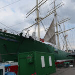
The Cap San Diego is a general cargo vessel, which has been in duty between 1962 and 1986. Since then, it ...
If an industrial site is jokingly called the Eiffel Tower of the Ruhrgebiet Region, it seems to be quite an impressive ...
Despite the limited travel situation in Germany due to Covid-19, there are some quite interesting virtual airline projects in Germany ...
Preservatives, artificial flavors, abherents and more - there are countless potential food additives in our everyday nutrition. You might feel ...
The Burg Meersburg (Meersburg Castle) in the city of Meersburg is one of the iconic landmarks in the Lake Constance / ...
Zeppelinheim - the nominal reference in the name of the borough South of Frankfurt to the legendary German airships is ...
Two Olympic Gold Medals and multiple other medals and World Cup victories (with a special focus on Super-G) - undoubtedly, ...
There are periodically discussions, whether the Cologne local transport is upgraded by cable car traffic over the river Rhine. However, ...
Undoubtedly, Munich Olympic Tower is one of the iconic buildings of the Bavarian city. Even though the tower is located ...
Gronau in the Münsterland region in Western Germany calls itself the "Music City". The some 50,000 inhabitant town is definitely not the ...
The city of Dortmund in the Northeast Ruhrgebiet region is maintaining its own airport. Dortmund Airport, which is officially called Dortmund ...
The Weiße Rose / "White Rose" was a resistance group during the German Nazi regime. Mainly consisting of university students, she ...
The Berchtesgadener Land is not only nowadays well-known as a popular tourist destination, there is also a dark part of ...
A museum with 90 vintage cars and so-called Yountimers might not feel to thrilling. If you add that about half of ...
Even though I could likely never have a maritime life (I would feel too locked away on a ship), I ...
A place about and full of chocolate - I am quite sure that I am not the only one who ...
The marketing flyer of the Museum Prototyp in Hamburg is really self-confident. The name of the car history museum is not ...
I had a couple of overnights in Frankfurt during 2020, some of them motivated by rail trip connections. In October ...
The Meyer Werft in Papenburg is one of the most iconic plants of German engineering, indeed. The site is manufacturing ...
Due to a late rail arrival at Munich Central Station, I looked for an overnight opportunity around the central travel ...
Even though architecture is a topic which so much influences our everyday life, the German Architecture Museum (Deutsches Architekturmuseum - ...
The Munich Toy Museum is one of these typical hidden gems you find in many cities. Right in the city ...
While I have a couple of "PCR professionals" in my circle of contacts, it took me until December 2020 until ...
I haven't been to too many hotels which are featured in own wikipedia articles in my life. One stay, at ...
The Deutsches Museum (German Museum for Science and Technology) in Munich is one of the most fascinating places in Germany ...
Due to the early departure of an ECE 451 ride from Frankfurt to Milan in September 2020, I looked for ...
Cologne Cathedral is the key attraction of my home town Cologne, of course (it is even one of Germany's very ...
Doing some local attractions in the Papenburg region like the huge Meyer Werft shipyard, the Dat Otto Huus in Emden or ...
There is no better start of the day for Munich people than a Weißwurst breakfast with a prezel and a beer. The Weißwurst, ...
Before Germany went to a lock-down of touristic travel in November 2020, I had a short trip to Munich. For ...
Though there is the amazing tiny Zeppelin Museum in Meersburg, not too far away, people tend to think about the ...
During an October 2020 trip to the East Frisia (Ostfriesland) region, I just could not prevent myself to have a ...
For a stay in September 2020, I tested the Hilton Garden Inn Munich City West for two nights, Friday to ...
Frankfurt is the banking capital in Germany and one of the key financial centers of all Europe.Thus, it may not ...
After having a couple of hotel reviews from nearby cities Dusseldorf and Bonn already, I felt it was a huge ...
Spending the weekend in a hotel dedicated to chocolate? Does not sound too bad, doesn't it? When my wife spotted ...
There are just a couple of toll roads in Germany (if you neglect road toll for trucks). One of them ...
Nuremberg is deeply linked to the German Nazi regime between 1933 and 1945. The key reason for that are of ...
On a trip from Cologne to Northwest Germany in early October 2020, I was looking for an overnight in the ...
Similar to the Europarad Ferris Wheel in Cologne, Munich is hosting a giant mobile ferris wheel, which is offering its ...
After we visited a couple of hotels in Bonn, we finally wanted to check out the only five star one ...
Especially in the recent past, I read a couple of ridiculous comparisons between certain people and political groups (which I ...
A legendary architecture (many people even regard it to be the most important building in the city), a sheer endless ...
Right before I departed in Frankfurt on day 1 of my Four Countries, Four Trains trip in summer 2020, I ...
One thousand kilometres to the sea - or vice versa One thousand kilometres to the Alps - was the slogan a new private ...
Also due to the current situation in aviation, I could follow my idea to invest more time in rail travel ...
The Königssee (literally: "King's Lake") is a beautiful lake in Southeastern Bavaria, not too far away from the Austrian border ...
Sometimes, you just have to be creative: if you have one of the biggest mobile ferris wheels in the neighboring ...
In order to have a more comfortable (and longer) sleep, I decided to go for a night at the ibis ...
The Elbphilharmonie (Elbe Philharmonic Hall), which has been built between 2007 and 2016 and opened on 11th January 2017, is something like ...
While - especially for business reasons - trans-European rail connections may still take too much time for daytime transfers, night ...
The Rheinturm - or Rhine Tower - is definitely one of Dusseldorf's most iconic viewpoints. During a recent stay at the ...
As I had couple of Spain and Portugal trips planned for summer 2020 and all have been cancelled due to ...
What is Germany's most popular tourist attractions? According to many popular rankings including TripAdvisor, it is neither the Brandenburg Gate ...
Aviation fans likely first think about the zeppelins when it comes to Friedrichshafen, Germany. However, the city is also home ...
IntercityHotels are a quite interesting joined venture of the German Rail System (Deutsche Bundesbahn, which was a fully state-driven company ...
Arriving at Munich Main Station by rail at 22:00, grabbing a rental car there at 8:00 (earliest possible time during ...
Heading back home. As said in the Day 3 coverage, I did not expect too much going on on that ...
So excited to travel again and do a proper. I did my first day of the rail rides through Germany, ...
After having so many trip reports involving flights and road trips, this trip report will completely leave me on the ...
If you travel in the Western Lake Constance (Bodensee) area, you have a choice of transport: you can either shortcut ...
The "Flower Island" Mainau is one of the key attractions of the whole Bodensee / Lake Constance region. No doubt that ...
Hamburg has a lot of famous attraction: some might first think about the huge harbor, others about the new Elbphilharmonie (Elbe ...
For my June 2020 stay in the Salzburger Land / Berchtesgadener Land area, I decided to go for two nights ...
Fancy a round of golf in the Lake Constance area? The reason why I chose the Golfhotel Bodensee ("Golf Hotel ...
Whenever you happened to watch Bobsleigh races in TV, did you also often think about how it is like to ...
The last night of my Lake Constance trip in May/June 2020 was at Constance. I did not went for one ...
On 1st July 2002, Überlingen at Lake Constance (Bodensee) gain notoriety not only in Germany: two planes, a Tupolev TU-154M ...
The city of Venlo in the Netherlands is maybe some sort of perfect illustration of profiting from the Schengen Agreement, ...
On my Whitsun 2020 trip to Lake Constance, I made a stop en route - due to the Covid-19 regulations ...
The Pfahlbauten (Lake Dwelling) at Unteruhldingen, prehistoric houses built on wooden piles, are one of the Top 5 attractions of the ...
During my Covid-19 day trip to Berlin, I spent some time in the Berlin Zoo. Berlin is quite famous for ...
Air ship and zeppelin flights / flight history is a quite popular part of a visit at Lake Constance. In ...
Many Germans did it - and I did it as well: travelling again. The Whitsun weekend was not only a ...
Coming back from London from the (finally cancelled) Country To Country Festival 2020 was the last trip I took before ...
Apart from some hiking and a number of drive-in cinemas, I did not generate any new contents for Flyctory.com on ...
After I recently visited the traditional drive-in movie in Cologne and the additional pop-up Car Watch in my home town, 2nd ...
As I wrote in my recent review about the traditional DRIVE IN movies in the South of Cologne, drive-in movies ...
Quarantining, social isolation, being unable to go out on a Friday - overall, the cultural and social scene has been ...
A Calculation Museum? Sounds like a place for die-hard nerds - but the Arithmeum in Bonn is really a popular ...
Why not doing it at home? Though Bonn is just some 40 kilometers away from our flat, my wife and ...
If you fly a non-Schengen flight from Terminal 1 (the non-Lufthansa one) at Munich Airport and depart from the B ...
After I had some stays at Hilton Munich Airport in the past, I was happy to be back in this ...
The reviews I found so far are quite clear: 9 out 9 users assigned a 1.0 to the Eurowings Lounge ...
The Historic Mustard Mill in Cologne ("Historische Senfmühle Köln") is quite a unique place in the million people city. It ...
After reviewing four Christmas markets in Cologne recently, I did not expect to get in touch with any additional ones ...
The Christmas Market in Cologne's Old Town is the largest of the city. Under the slogan "Heinzel's Wintermärchen" (something like Good ...
Cologne Cathedral and a 25 meter high Christmas tree - these are the key ingredients, which turn the Christmas Market ...
As an overnight stay after the Mrs Greenbird concert in Frankfurt, I decided to opt for a hotel chain, which ...
You may know Mönchengladbach (or: Moenchengladbach) for soccer, likely. However, the city hosts one of the most remarkable Star Wars ...
During each festive season, Cologne is crowded with tourists and visitors due to its Christmas markets. There are masses of ...
In an evening session with German aviation experts and frequent travelers in Frankfurt, Lufthansa today revealed their new Miles & ...
As I needed an overnight after Eric Paslay's show in Aschaffenburg, I was looking for a stay in rail station ...
Though it just processes about a half of the number of passengers of Munich Airport and even just a third ...
The Johanniter Gästehaus in Münster in Northern Northrhine-Westfalia is likely one of the most unusual places I stayed in the last ...
Like you already saw in my review of the Emirates Aviation Experience, including the A380 simulator, I have a certain ...
The Vulkaneifel region Southwest of Bonn, Germany, is still a quite active vulcanic region. Thus, all around there and in ...
The next cities around are Trier, Sankt Wendel or Idar-Oberstein - the small city of Hermeskeil could be seen as ...
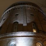
Water towers are not too common in Central Europe, especially in Germany. This is definitely one of the key factor, ...
After I mentioned the Air Canada Lounge at Frankfurt Airport already in my love letter posting to LATAM flight 705, ...
After two days of Weird Al Yankovic concerts and a memorable Day 4 with my sports idol Leander Paes and ...
Flying back from the Write Like A Girl event in London, I had the opportunity to fly Sun-Air of Scandinavia for ...
My trip to Singapore and Malaysia was my debut First Class experience (apart from Domestic First in the USA). I ...
Solingen, some 30 km Northeast of Cologne, is known as Germany's headquarter of the knife and scissor industry. Thus, it ...
For customers flying on Lufthansa's top notch First Class product (and HON Circle Members), the German airline offers a very ...
I already visited a couple of stadium tours with Flyctory.com in the past. My home and heart soccer club, 1 ...
Wuppertal in the Bergisches Land region Northeast of Cologne hosts a very special attraction for train and rail enthusiasts: the ...
Bad times of terror, being pried and controlled in a country without the freedom to move - or good times ...
Did you ever copy a CD from a friend? Plagiarism can be much worse than just bootlegging. The Museum Plagiarius ...
The Lufthansa Lounges for Senators and Business Class customers are tending to be too crowded, especially in peak times. Thus, ...
Due to a career event of my wife, we had to travel to the trade fair area of Hanover in ...
During our visit of the Country 2 Country 2019 in Berlin, we chose the Hampton by Hilton Berlin East Side ...
Lindlar, a minor Eastern suburb of Cologne, hosts one of two open-air museums driven by the regional Rhineland authority LVR ...
Bergisch Gladbach, a 110,000 inhabitant city East of Cologne, is a traditional location for the production of paper. While nowadays, ...
After I visited the Sinsheim sister museum in February, I have been very curious about visiting the Speyer Technology Museum ...
The B&B Hotels group, mainly operating in Germany, operates in the quite strongly growing of budget hotels. When you book ...
One of the key attractions in Ratingen, Northeast of Dusseldorf, is the remarkable Cromford Textile Factory, which is driven by ...
When people think of real "Eau de Cologne", they typically think about the well-branded 4711 brand located in the city's ...
There are quite a lot of minor deer and animal parks around Cologne, quite a lot of them mainly based ...
The route between Cologne and Rostock is a quite traditional connection from Rhineland to the Baltic Sea - which has ...
Due to the limited exhibition space of the "Deutsches Museum" (German Museum of Technology), the famous Munich educative center had ...
Located North of Cologne, the "Wildpark Tannenbusch" offers a nice way to spent your free time with your family, enjoying ...
"Stylish", "Surprising" or "Modern design" might not really be the attributes which you combine with ibis hotels. The more I ...
As I for example stated in my review on Louvre Abu Dhabi, I am quite much interested in ancient cultures ...
Spa Town Bad Münstereifel, suffering from economic problems in their city center, decided to revamp its commercial concept and opened ...
If you collect and something, you likely also have one or more several favourite pieces in your collection. What do ...
The Cologne City Museum's recent history is not really what one would call "lucky". After a water damage in later ...
Maybe one of the most characteristic German products is bread. I even found "German bakeries" during my visit of Taipei ...
More than 1,100 rooms in the German capital - the Estrel Hotel in Germany's capital Berlin is just a massive ...
Sunday, 27th May 2018 - time to slowly head home. After quite a lot of flying, this has really been ...
No, I am not going to travel between Europe and Asia or America like a madman or do some extreme ...
Located quite prominently right at the motorway A6 at Sinsheim (home of the TSG Hoffenheim soccer club), the Technik Museum ...
Historic Museums
Here are all other postings on Historic Museums:
With the United States of America celebrating their 250th birthday, I felt it is a good opportunity to head back ...
When you think about the Victoria & Albert Museum, you likely think about their main outlet at Cromwell Road in Kensington, London ...
Especially based on the fact that the Belgian capital is just some two hours away from my residence, I comparably ...
When I visited the Women Handball World Championships 2025 in Trier, my hotel was in Luxembourg. Almost every day, I ...
The Münchener Residenz ("Munich Residence") is one of the most iconic places in Munich. From 1508 to 1918, it was home of ...
I did not have too much time in Jakarta, when I visited Indonesia in October 2024. On top of that ...
The Prater is one of the key touristic areas of Vienna. I already took you to several places located within ...
The Harz region will always be a special place to me. I studied mathematics at Clausthal Tech University and thus ...
The story of Bryggens Museum (or Bymuseet in Norwegian) started with a calamity. A fire in 1955 ravaged parts of the ...
Already in 2022, I introduced you to the very interesting Saga Museum in Reykjavik, Iceland. However, there is a similar ...
During my trip to Albania, I learned a lot about the situation of the country during the socialist times. Especially ...
The Goldenes Dachl ("Golden Roof") is regarded to be the most famous and iconic architectural structure of Innsbruck. The palatial oriel has ...
Some 2,000 years ago, the Romans controlled a wider range of Europe. They even made it to (nowadays) Luxemborurg. One ...
I already introduced you to two places driven by the Faroe Islands National Museum (orTjóðsavnið in local language). Namely, these ...
The so-called Negro Leagues were an episode in US-American baseball. Based on the separate but equal principle, these leagues were for black ...
Poland suffered massively under the German occupation and the Second World War. Thus, it is not that surprising that Gdansk ...
When I visited Vienna in June 2024, I wanted to spot a wide range of the city's attractions. Among them ...
My April 2024 Pittsburgh Penguins trip brought me back to Washington D.C.. I decided to add visit some places, which ...
A musieum about nuclear power and atomic bombs? Sounds like a place which is either a great scientific one - ...
As I am traveling to the United States rather frequently and also love to follow Feli from Germany (formerly German Girl in ...
Going back from Las Vegas to Los Angeles after the New Year's Eve celebrations, my wife and I opted to ...
I really like the museums in Sharjah. One of the museums I visited in the city right North of Dubai ...
Even if you visit Cyprus due to the nice climate and the beaches only, you might make it to Nea ...
There are so many art museums and technical museums out there. However, do we really care sufficiently about the items ...
The Presidents Hall of Fame is having quite some fame, even though it is not located very close to the ...
Typically, people associate Myrtle Beach in South Carolina with fun and leisure activities. Enjoying the sun at the beach, hanging ...
The Arabia steamboat is something like what the Vasa is for European ship history (just dated a few centuries later...). The side ...
Not only due to his 1963 speech in Berlin, John F. Kennedy is definitely one of the most popular US-American ...
I already introduced you to Bunk'Art 1, a former nuclear-proof governance bunker in the outskirts of Tirana. The huge area ...
Under the leadership of socialist Enver Hoxha, a massive number of bunkers has been built in Albania The German wikipedia ...
The Museum of Jewish Heritage in New York City also calls itself A Living Memorial to the Holocaust. Even though I ...
Kourion Archaeological Park has definitely been one of the highlights of my trip to Cyprus in October 2023. However, this ...
My wife and I really enjoyed our trip to Cyprus in October 2022. So far, I have introduced you to ...
If you are in Dublin and feel to learn something about the history of the city and Ireland in general, ...
If you nowadays look at the map of Cyprus, you won't find any rail-driven vehicles. However, the country did have ...
While I so far introduced you to parts of modern life in Cyprus, the Mediterranen island is full of history ...
Its own website states The National World War I Museum and Memorial to be the The World's Most Comprehensive WWI ...
The last posting of the year - Best Ones 2022 is introducing you to my best experience last years (as ...
No matter if you like his characteristic tomato sauce or not, Senator John Heinz (yeah, the ketchup guy...) is one ...
The Pergamonmuseum is one of the key touristic places in Berlin. The museum features over 250,000 objects of German-lead excavations ...
Kolossi Castle is one of the key landmarks in Southern Cyprus. The castle has been a stronghold for the Crusaders ...
The world largest collection of weapons - luckily, this weaponry is not the result of a weird US-American NRA believer, ...
Especially when I visit large places, which demand and deserve a major number of pictures, it may take quite some ...
One of the activities I can recommend most in Sharjah is going to a museum. I introduced you to quite ...
Many oeople visit the Canary Islands just due to the reliable climate and good weather. However, there are some really ...
The area around Trier is holding a bunch of records for the oldest buildings and structures in Germany. The rationale ...
The most picturesque tour stop while following the first three concerts of the Weird Al Yankovic Tour 2022 in April ...
During the Nazi regency in Germany, the Emslandlager (Emsland Camps) was a group of concentration and detention camps in the Emsland region, ...
I am not that much into coins and numismatic collections - but when I visited Graz in Austria in summer ...
I felt really happy to have a deeper view to the Northern and East parts of the United Arab Emirates ...
When I had another trip watching my favorite musical Rock of Ages in June 2022 in Portsmouth, I had the rare ...
There are a few Turf House Museums you can visit in Iceland. The UNESCO is even thinking about putting this ...
Apart from the legendary Blue Lagoon, the Viking World / Vikingheimar in Nardvik on Reykjanes is likely one of the most ...
I am not a religious person at all. The more, it is somehow remarkable that this posting is already the ...
During a trip to the German North Sea shore in later 2021, we also visited the Automobil- & Spielzeugmuseum Nordsee. The ...
The Settlement Exhibition Reykjavik (sometimes also with an added ± 871) gives you an insight of the 10th century settlement ...
After the end of World War II, the blocking of access to West Berlin by the Soviet Union (the so-called Berlin ...
My trip to the United Arab Emirates in February 2022 majorly lead me to the Northern part of the country ...
Germany between World War II. - this is roughly the mission of the House of the History of the Federal ...
Bellver Castle - or Castell de Bellver - is one of the most iconic places of Palma de Mallorca. The ...
You might not make it to the Mallorca city of Manacor just to visit their history museum - but the ...
When I visited the harbor-area attractions in Reykjavik, I felt it is a good opportunity to share as many of ...
Hauptstadt der Spione - "Capital of the Spies". This is a book, which you can buy at the souvenir store of ...
In quite some postings about the emirate North of Dubai, I already stated how much I value and enjoy the ...
Quite a while ago, I took a trip to Arnhem in the Netherlands to explore the rich WWII history of ...
It is time for the final posting of the years, simply named The Best Ones 2021. After looking into my ...
The Tränenpalast ("Palace of Tears") in Berlin is the former border crossing point between East and West Berlin. It is located at ...
Venice is an iconic place by itself - but it has some real key attractions as well. Without a doubt, ...
While Palma Cathedral or the Palma Arena are regarded to be iconic pieces of architecture in the Balearic capital, I ...
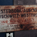
The same faith which applies to Oswiecim in Poland (better known under the former German name Auschwitz) is also valid, ...
Auschwitz is a town's name (adopted to German) which you typically link with murder, cruelty, state-organized mass killings, injustice. A ...
Driving a model landscape or a large model train landscape in Germany is a difficult business: Even if you do ...
There was a duplicate reason to visit the European Hansa Museum in Lübeck in late July 2021: apart from the ...
Not only because auf an early 1990's video game, I am deeply interested in the Hansa and its history. Thus, ...
As I said in other posting, I really enjoy being in Sharjah and feel the vibe of the city and ...
A very interesting rebranding: when I started to explore museums in the nearby Netherlands, the Dutch Freedom Museum in Groesbeek ...
It is almost needless to say that Adolf Hitler was obsessed with megalomanic ideas. Apart from ruling the world and ...
Sharjah is very often underestimated as a touristic destination. In fact, it offers some very interesting museum. The most outstanding ...
The Stadium of Domitian - or Stadio di Domiziano, as the locals say, may not be one of the classic tourist ...
The Northern Ireland conflict - or simply called The Troubles is one of the most intense civil conflicts I experienced during ...
The National Monument Camp Vught - or Konzentrationslager Herzogenbusch, which has been the German name during the Nazi era - is ...
Papenburg has some more interesting places other than the famous Meyer Werft. At the opposite part of the town, my ...
Abu Dhabi Khalifa Park is one of those hidden gems which you typically don't find in travel guides (or at ...
The story why I felt I had to visit the Bergisches Museum für Bergbau, Handwerk und Handel - the Bergisches ...
Even though the Netherlands capitulated against Germany just after a few days under attack during World War II, they have ...
There are so many interesting places in Hamburg, which are still on my bucket list. Of course, the Northern German ...
While the Arabian word Etihad for many people first of all stands for a major airline based in the capital of ...
Giacomo Girolamo Casanova was born on 2nd April 1725 in Venice. The author and adventurer is definitely a legendary Italian ...
Nuremberg (or Nürnberg, how it is named in German) has some sort of tough political-historic heritage. Several sites still remember ...
In 1944, the 101st Airborne Division, called Screaming Eagles, landed North of Eindhoven in the Netherlands. As part of the Operation Market ...
When you visit Dubai or the United Arab Emirates in general, you likely think about the parks, skyscrapers, sun and ...
In 1891, Henry B. Plant founded the Tampa Bay Hotel. Nowadays, the National Historic Landmark in central Tampa is no ...
Schloss Burg is just about half an hour away by car from my home town Cologne. The castle on the ...
During a prolonged stop-over at Manchester Airport, I grabbed a rental car for a day and did some sightseeing in ...
The Burg Meersburg (Meersburg Castle) in the city of Meersburg is one of the iconic landmarks in the Lake Constance / ...
It is not even full sure whether Christopher Columbus in fact visited the Columbus House in 1492, before he left ...
Two Olympic Gold Medals and multiple other medals and World Cup victories (with a special focus on Super-G) - undoubtedly, ...
I am really fascinated by Leonardo da Vinci and his concepts / inventions. Thus, during my summer 2020 visit to ...
The Weiße Rose / "White Rose" was a resistance group during the German Nazi regime. Mainly consisting of university students, she ...
The Berchtesgadener Land is not only nowadays well-known as a popular tourist destination, there is also a dark part of ...
The historic Al Shindagha district in Dubai, located right South of the Dubai Creek, is currently undergoing quite some touristic ...
You might find this statement multiple times within my December 2020 postings - but A Christmas Carol by Charles Dickens is ...
Undoubtedly, Amsterdam is not just a beautiful city, but also a place of rich cultural history. One example for that ...
The Munich Toy Museum is one of these typical hidden gems you find in many cities. Right in the city ...
Fujairah is definitely quite underrated as a touristic destination in the United Arab Emirates so far. I have to give ...
Nuremberg is deeply linked to the German Nazi regime between 1933 and 1945. The key reason for that are of ...
Especially in the recent past, I read a couple of ridiculous comparisons between certain people and political groups (which I ...
During my first visit in Singapore, I just wanted to have an overview about the history of the Asian city ...
When you think about Nazi Germany murders, you typically think of extermination camps like Auschwitz or the concentrations camps. A ...
The Mithraeum in London is maybe one of the hidden gems of the British capital. During exvacation works in London ...
One for the most positive surprises of my early July 2020 trip to Amsterdam and Eindhoven was the Channel Museum ...
When people think about the United Arab Emirates, they typically think of Dubai or Abu Dhabi. During my last trips, ...
The Imperial War Museum operates five sites throughout Britain. While I already visited the interesting Churchill War Rooms, I was ...
At least in the Cologne area where I live, Castle Arcen in the Netherlands, close to the German border, is ...
On 1st July 2002, Überlingen at Lake Constance (Bodensee) gain notoriety not only in Germany: two planes, a Tupolev TU-154M ...
The Pfahlbauten (Lake Dwelling) at Unteruhldingen, prehistoric houses built on wooden piles, are one of the Top 5 attractions of the ...
I am not too much of a casino person. However, I love being in Las Vegas as it is also ...
A museum about the history and importance of sea trade in Singapore and Southeast Asia? Sounds much more boring than ...
The Historic Mustard Mill in Cologne ("Historische Senfmühle Köln") is quite a unique place in the million people city. It ...
On the third day of my Weird Al Yankovic & Grass Court Tennis trip in July 2019, I had time ...
One amazing feature of Washington D.C. is the massive number of museums driven by the Smithsonian Institution: they are typically ...
Even more than 80 years after Elvis Presley's birth, Tupelo in Mississippi is still dominated by memories of its most ...
As part of a company event in Paris, I was able to see the Tutankhamun exhibition. Until the completion of ...
Solingen, some 30 km Northeast of Cologne, is known as Germany's headquarter of the knife and scissor industry. Thus, it ...
Founding Father of the United States, printer, author, inventor, scientist, many more... It is likely much easier to list the ...
Bad times of terror, being pried and controlled in a country without the freedom to move - or good times ...
Lindlar, a minor Eastern suburb of Cologne, hosts one of two open-air museums driven by the regional Rhineland authority LVR ...
When Germany intensified their offensive efforts during World War II, Winston Churchill decided to built a bunker in Central London ...
Something we all have in common is that we went to school - at least for a certain time. The ...
How would a visit of Thessaloniki be completed without looking at the ancient Macedonian Times? Visiting the Archaelogical Museum of ...
Liverpool has been one of the most important European cities for slavery trade. Thus, I used my September visit at ...
When people think of real "Eau de Cologne", they typically think about the well-branded 4711 brand located in the city's ...
On 21st October 1941, the German Wehrmacht slaughtered thousands of civilians in Kragujevac, Serbia, to revenge dead and wounded soldiers ...
As I had just limited time in Antwerp after the enjoyable VLM flight, I chose to visit the Snijders&Rockoxhuis, which ...
Casa Loma in Toronto is North America's only full sized castle. Though it might not be that well-known here in ...
The Royal Ontario Museum just feels like an amazing wonderland of topics, a bit of "something for everyone". Did you ...
As I for example stated in my review on Louvre Abu Dhabi, I am quite much interested in ancient cultures ...
The Cologne City Museum's recent history is not really what one would call "lucky". After a water damage in later ...
Maybe one of the most characteristic German products is bread. I even found "German bakeries" during my visit of Taipei ...
My honest first idea about "Louvre" is that it is a place in Paris where people queue and punch to ...

 by
by